Real store listing · independent assessment pending.

2.0 ★17 ratings
—Downloads
4+Age rating
114 MBApp size
Free · In-app purchasesIn-app purchases
About this app
Capture, Tag, Remember. All in One Place.
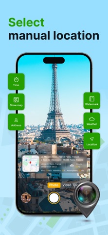
Geotag Photos & Camera Map is your ultimate companion for capturing memories with precise location context. More than just a camera, it's a powerful tool that automatically tags every photo and video with GPS coordinates, weather data, and creates a personal visual map of your adventures.
Key Features:
All-in-One Media Hub: Seamlessly switch between high-quality Photo Camera and Video Recorder right within the app. No need to jump between different applications.
Automatic & Rich Geotagging: Every shot is automatically embedded with precise GPS location (latitude/longitude), address, and even real-time weather conditions (temperature, conditions) at that moment. Never forget "where" or "when" again.
Your Personal Camera Map: Visualize your life's journey on an interactive map! See all your geotagged photos and videos displayed as pins.…
Preview
Real screenshots from the store listing.



Independent evidence report
Evidence and review signals
This is where the page changes from an app-store listing into an evidence report: findings, important reviews, pricing and a dated history.
What we measured
Each line is a measurement published as a measurement, never a verdict.
Each line is a measurement, published as a measurement. Where we have not looked, the line says so rather than reading as a zero.
Developer replies to reviews
Not assessed
Fewer than 50 reviews scanned — too few to state a rate
Price in the store description
States no price and billing period
Cancelling, in the store description
Does not say how to cancel
Themes reported by reviewers
Not assessed
This app's reviews have not been assessed yet
Five-star share of ratings
Under 65% five-star
Arithmetic on the stores' own published rating counts. It says nothing about why the ratings fall where they do.
In the package we scanned
No package has been scanned for this app, so nothing is published about what it ships. That is an absence of evidence about the app, not a finding about it.
Graded bands · predicate set 1.4 · how these are measured
What the analysis found
App-specific findings, grouped by what each one rests on. How they are graded lives on its own page.
No review themes cleared the reporting threshold.
Assessment & version history
App changes and Appworthy events in one timeline.
What this app sells
Useful store-disclosed pricing, kept below the app listing.
Items shown1
Lowest$24.99
Highest$24.99
Premium Subscription - 1 week$24.99